|
|
||
|
|
FORUM:
|
|||||||||||||||||||||||||||||||||||||||||||||||||||||||||||||||||||||||||||||||
Modernizing the Colony: Ports in Colonial Philippines, 1880–1908Dídac Cubeiro
|
|||||||||||||||||||||||||||||||||||||||||||||||||||||||||||||||||||||||||||||||
|
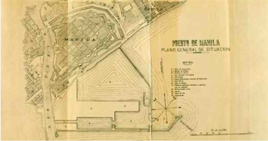
The revolution in the maritime transportation that began with the emergence of steam powered oceanic travel in the mid-nineteenth is closely tied to the development and expansion of colonial port cities, much of which occurred to facilitate the extraction and export of the products of plantations in colonial hinterlands by the end of that century. This essay begins with a brief explanation of how technology drove the expansion of both maritime trade and necessarily drove the modernization of port facilities world-wide. It then focuses on how the modernization of the ports of the Philippines provides both an example of, and also a model perhaps for understanding colonial port operations during the late nineteenth and early twentieth century during what is often called the Age of High Imperialism.1 The Modernization of Global Trade Entrepôts During the nineteenth century, there were many advances in the maritime transportation industry that spurred long-distance trade and lowered shipping costs.2 The introduction of steam power and nautical maps that included information on winds and currents are most often cited as drivers of that era's expansion of global commerce. However, of equal importance was the linkage between improvements in steam power and advances in metallurgy which combined to stimulate the building of larger vessels. By 1870, steam moved larger ships built of iron instead of wood. By 1880, to reduce the weight associated with iron construction, steamers were increasingly made of steel. Eventually, more powerful engines built to consume less coal for fuel, allowed ships to make longer trips without refueling. Still, the large merchant fleets in the late 19th century employed by Britain, Germany, and the United States, needed to establish coal depots along the longer trade routes to supply their larger ships, and process of the modernization of harbors began.3 That process—the development of harbors of greater depth and expanded auxiliary infrastructures—was also driven by the increased production of colonial plantation economies and associated technologies to serve a rapidly growing food industry. These technologies included cargo cooling on ships, improved the delivery of perishable foods, mainly fruits, such as pineapple or banana, which were no longer damaged during transportation. These, in turn, drove the integration of the plantations of the Caribbean, Central America, Equatorial Africa or Southeast Asia in the international markets. Some companies like the United Fruit Company invested in their own fleets and in the infrastructures of ports and railways to access to their plantations.4 The railways reduced the times of storage, load and unload of the cargo to the ships, with the lines arriving direct to the docks as in the case of Manila. The state, usually granting concessions, invested in railways, ports, lighthouses, roads and telegraphs to create a commercial platform for export. Among the first of such railways was the railway in India, connecting the productive hinterlands of what is now Mumbai with its international port. Such railways also allowed the penetration of European, North American and Japanese manufactured imports.5 Expanding port facilities not only allowed access to products, but also facilitated the work of colonial insurance companies, warehouses, and communications. Prior to the arrival of submarine cables, the fastest ships carried the mail. A trip from Spain to the Philippines took a year in the 17th century and a hundred days in 1850. By the end of the 19th century, travel from Barcelona to Manila only took a month.6 Focus on Asia It is well known that much of the development of port cities in Asia was due to the connection between the Red Sea and the Mediterranean following the opening of the Suez Canal in 1869.7 The opening of the Suez Canal shortened the route between Europe and Asia and increased sea traffic from the Indian Ocean to China. The main ports of Southeast Asia were expanded and connected with the inland to improve their exports to their colonial metropolis. Spain expanded the port of Manila, Philippines, in 1885 and connected it with the railway in 1892 to Dagupan.8 England expanded the port of Hong Kong, China, in 1885 connecting it with the railway in 1910, to Canton.9 Holland extended the port of Batavia, Tanjung Priok, Indonesia, in 1886 and connected it with the existing railway in 1864 that circulated between Batavia and Semarang.10 France enlarged the port of Haiphong, Vietnam, in 1887 and connected it with the Hanoi Railway in 1910 headed to Yunnan in China.11 As a result, by 1871 most major ports in Asia were connected by the telegraph, mainly used to transfer funds between bank accounts that settled balances between bank branches. The increase in transactions led to a financial bubble that mainly affected the London Stock Exchange, which focused on shipping, food, mining and railway company stocks in the late nineteenth century.12 The Global Expansion of Port Facilities and the Philippine Plantation Economy The Philippines were very much a part of this modernizing scenario. The capital city and the historic main port of the archipelago, Manila, was located on the largest island of the Philippines, Luzon, with its enormous hinterland. The opening of the Luzon railway in 1892 significantly reduced the transportation costs of products destined for export: sugar, rice, abaca, copra, tobacco and, in a minor way, coffee.13 The railway transported these products at reasonable prices both from farms to production and consumption centers locally and internationally. Railways also facilitated foreign and local investors in plantations to reach more distant production centers and markets.14 The latter was vital once the reorganization of the colony towards an export plantation economy by the Spanish crown completed as it was designed to self-finance the budget of the Philippines, which was very expensive to maintain for the Spanish treasury due to the inefficiencies of long distance administration between the archipelago and Europe. The introduction of the railway had a dramatic effect on the economy of the island. Manila expanded its area of influence and moved resources and population to take advantage of the efficiencies of the raillines 15 Like today's "developmental highways," the railway established a route of development for the region, providing the vertebra for Manila's expansion of its economic, demographic and social influence.16 This line connected the most productive areas of Luzon, close to the provinces of Batangas and Lipa, where the larger sugar plantations were located.17 A similar process occurred to the south, on Panay (its main city is Iloilo), Negros and Cebu, located in the archipelago of the Visayas, where rice, abaca and copra were produced. The abaca was used for the manufacture of ropes of great strength and resistance. The coconut oil extracted from the copra was used for the extraction of glycerin and the manufacture of dynamite, a common explosive at the end of the 19th century. The arrival of the railway to Cebu and Panay, projected under the Spanish administration and built by the Americans in 1907, concentrated the population near the railway lines and further promoted the existing plantation agriculture.18 Connecting the Port of Manila with the Railway Upon the arrival of the U.S. Administration, the single axis of communication of Luzon ran along the railway built by the Spanish Administration.19 The main railway line connected the cities of Manila and Dagupan, at the Lingayen Gulf, and its operation was owned by British company (the Manila Railway Company Ltd) which had received grants to connect the railway stations in Manila and Dagupan with their ports. Coastal shipping was the other major transit system in Luzon late in the nineteenth century, and its connection with rail deliveries was virtually indispensable. The sea operations connected the internal network to international trade, the chief source of income for the Philippine economy. An acknowledgement of this fact as represented by the connection between the station terminal and the dock at Dagupan, was posted on January 4, 1898 in the Gazette of Manila from a Royal Order dated October 20, 1897, which declared that it was not a mere tramway, but a vital source of port-related commerce.20 Unfortunately, there were only three ports that allowed for international trade: Manila, Iloilo and Cebu; the rest were in natural harbors that worked well for coastal navigation, but were too shallow to service the heavy transport ships used for the international transportation of goods. There, coastal shipping continued as the main means of transporting goods during the second half of the century as the existing road network required constant maintenance as a result of heavy rains. Rather than attempt a costly expansion of port facilities, the Dirección General de Obras Públicas, which received funds for infrastructure investment in the Philippines in the late nineteenth century, focused on projects and improvements at the international ports initially Manila and thereafter at the ports of Iloilo and Cebu, although the U.S. Administration was responsible for re-built the port in Cebu. 21 Widening the port of Manila 1881–88 The Spanish Board of Works, Port of Manila, held its first session on March 22, 1880.22 The session started as a study and handling of a port-widening project focusing on the entire port of Manila and the partial services that accompanied it. They also began to study the needs for the technical and mechanical works required for such an important project.
In late 1881, the engineer responsible for the project envisioned his task as having three sections. The first section was laid out in Obras de caracter general. This document addressed the development of infrastructure in the area that would be required by the new port and access to it. It discussed the need to purchase necessary instruments of measurement, acquire topographical drawings, and identify relevent prior work done by the Port Central Office. It also described several research initiatives conducted in laboratories as laboratory tests and at sea to evaluate the corrosion resistance of building materials, including cement, required for the construction of the dams. The second section, Construcción del Nuevo Puerto, discussed the offices, dams and railways required for the expansion of the old port and new construction. According to this plan, engineers built an office, a store and a blacksmith's office for tools as well as rooms for the workers. The construction of the necessary dams was supported by the opening of a quarry in the town of Angono, which was near Manila, and the second section outlined the area for the tracks needed to carry blocks of stone from the quarry to the dock and back, and also the need for a stock of powder and a bascule bridge for weighing the wagons leaving the quarry. Hand drills and cranes extracted the stone, supplemented, then a novelty, by two steam drills and steam generators. A railways system was developed for railways carrying ore to the site. Steam tugs would transport the stone block-carrying wagons to sea to facilitate that, the engineers purchased a speedboat and fourteen barges which were smaller boats used for transportation. But transporting stone blocks was not possible unless carried out by clearing a channel in the central area of the Pasig River, for which, eventually, a dredge was acquired. To protect the area which was dredged from the entrance of the sea, a small jetty was created on the beach of Santa Lucia.23 The third section focused on the preservation and improvement of the port's interior. The port area in Manila was a natural harbor open to the sea. The project intended to develop the Pasig River so as to service a port further inland. To achieve this, they were to extract 37,520 cubic meters of mud. Work was interrupted for six months due to the breaking of the manual dredge.24 This lack of resources prevented the improvement of the bar; the resultant narrow channel between the west bank of the dam and bank of the river disabled the use of the inner harbor for some time. The other important part of this section of the plan was the repair of the existing docks at Pasig. An additional complication soon arose, requiring the expropriation of houses and land on the right bank of the river. 25 From 1881 to 1887, the work was divided into implementation phases, the first between 1882 and 1885 and the second between 1885 and 1887. During the first phase work stopped, due in part to legal procedures associated with amendments added to the initial draft.26 However, laboratory testing continued to find suitable concrete conditions for the seaport. Meanwhile, the works in the quarry and on the docks proceeded, and a store was completed during the second quarter of the year.
Then much of the initial work that had been accomplished had to be rebuilt due to damage caused by two strong typhoons hit Manila Bay in the months of October and November 1882. A few months after the disaster, access to the quarry was restored and transport of the extracted stone to the river began via the purchase of barges and of an auxiliary steamboat to the train transporting the stones.
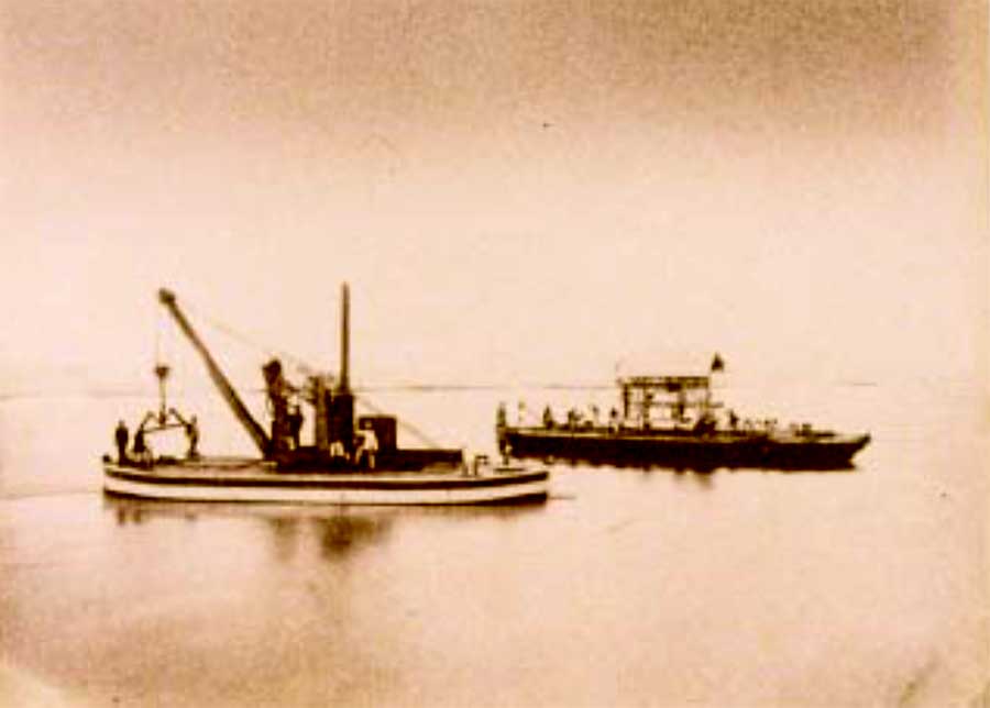
During the first years of this period, others entities had built dams in Taytay and Tipas. Another dam was started in Taguig. Government engineers continued the dredging of the entrance of Pasig and the required expropriation building along its banks were completed. Changes to the pier down river from the Bridge of Spain in Manila were then proposed. Next to the Harbormaster's building, near the proposed pier, they built a factory to manufacture cement blocks that were needed to complement the stone extracted from the quarry. In January 1883, the engineer responsible for the project, Eduardo López Navarro, was replaced by Genaro Palacios due to Navarro's illness. Palacios completed minor works that would be necessary for the execution of the final project. These included the completion of the headquarters, the extension of the pier loading area, the continuation of extracting stone from the quarry and collecting large amounts of soil and decomposed rock, alternating with the blocks of granite extracted. The workers moved the earth extracted to the pier because it was necessary to extend the pier to allow the boats to be moored there. This created the depth sufficient to enable loading transports, even in the dry season when the river had less water volume. To transport stone, negotiations began with Hong Kong to buy two tugs. Palacios intended to finish this before the works at the port were done, but eventually the government purchased two tugs of 130 horsepower capable of towing three barges at a time from the Satra Company in Lyon, France. These tugs were ordered on the first of December in 1884 but they could not get to the Philippines until June of 1885. Palacios did purchase a tugboat in Hong Kong, allowing them to start transporting stones. Moreover, he also ordered another dredger, from the Priestman Brothers in England. Workers soon acquired the necessary experience to use them and dredging work progressed at a good pace. Finally, in December 1884 they installed temporary moorings and they built warehouses to store tools and valuables.
On November 18, 1884, a typhoon of great magnitude again struck Manila Bay and left the dredge wood ineffective due to its poor general condition. In late 1884, workers repaired the docks at the Pasig, sidewalks were widened and the streets were paved with stone taken from the nearby quarry. Disappointingly, the second phase of the project, between 1885 and 1888 began with Palacios having to leave the position chief engineer. Also some of the most important tools, such as the dredge's wood parts, became unusable and more time was lost partly due to inclement weather. Not surprisingly, a feeling of helplessness appeared in the report submitted by the chief engineer Genaro Palacios:
Beginning in 1885 the transport and emptying the stone quarry to form the basis of the dams in the submerged part of the port was done with stone taken from the quarry. Between that and from the start of work, the price of cement had fallen 20%, from 34 pesos to 27 pesos per ton and this brought about the possibility of filling the tops of dams with cement blocks instead of using the stone quarry. To reinforce this idea, they calculated the cost of the extraction of stone, and they concluded that the stone was 60% more expensive than concrete blocks manufactured in the workshop. Based on these elements a modification of the project was presented to the Board in late 1885. That year, they also had to repair the roof of the office, as the typhoon had damaged it. To avoid possible repairs in the future for similar reasons, they decided to cover it with a galvanized iron roof, built on the former roof. It was completed in October of 1885. Moving to Completion One of the first needs that arose from the work on the port was the construction of essential buildings to place the machinery utilized for the manufacturing of concrete blocks and for warehouses needed to store the cement. These had to be located near the docks of the Pasig River. A workshop for the repair of machinery and tools, equipped with lathes, drills, cutters and punches was built.28 Two docks were built parallel to the beach in Tondo, one in order to repair the boats that were damaged at the port of Manila, and another in Cavite.29 These docks were also used for mounting the steam tugs purchased in France, which were finally delivered in September of 1885. Minor work projects included a telegraph line connection which started from the central office to all points of the works, even to the quarry at a distance of 26 km away. Another line went to the local observatory, in order to allow for time to warn about and announce possible storms and also to educate about the possible destructive effects of typhoons. Taking advantage of the fall of the tide, workers paved the esplanades reclaimed from the sea, by slowly filling in with the rest of the earth taken from the quarry area that later would be graved and paved. They dismissed the use of earth, which was mostly muddy as it came from the dredging of the port itself and would not support construction that would later be placed on the pavement.30 They lay the foundation by interposing cement blocks and sand and gravel to give more consistency to the ground grading. For land transport the quarry used the system of roads, along with portable cranes purchased from the Spanish companies Bazan, Megy and Echeverria.31 Wagons were filled with shovels in the quarry and transported to the dock, where with the help of the crane, barges carried earth to the part of the yard that was reclaimed. During the leveling works the crane had to be repaired several times, as the wood used for its construction weakened in the moisture and warmth of the Philippine climate. The crane was repaired with local wood. To advance the construction of the plains, a small steam locomotive was purchased to carry wagons from the quarry. The locomotive began operating in mid-1886 and was capable of carrying 25 tons. They used more than 100 wagons for transporting earth. Trains were formed of 10 carriages each, positioned either inside the quarry, at the beginning of the operation or at the docks for loading. All these works were carried out during the years 1886 and 1887. They reclaimed 55,934 square meters of the sea, taking 155,491 cubic meters of earth to form the terraces. Later they installed a steam crane for unloading ships, to begin operations for loading and unloading at the port of Manila. In 1886, they made an improvement at the quarry, collecting water from a small spring that was there. The planners decided to transport the water to the office store close to the quarry, providing it with water. They also built a small tank to supply water more easily to the locomotive that ran along the road to the port, to fill the boiler at both the quarry and the harbor, as they usually did. The volume of extraction was immense. The transport came to fill a barge daily. Four barges were used simultaneously, two as transports, one in each direction, and one at the origin loading and another unloading the cargo of the previous day. In order to unload the cargo, once the barges arrived, the floodgates were opened and the cargo was unloaded and they stacked stone blocks in the central part of the docks in the form of a wall, and when this natural wall got to the required height, the exterior was clad with cement blocks of smaller dimension. These blocks were in principle resting and simultaneously maintaining the structure of the dam before the onslaught of the waves took place and before strong tides caused wear. The other barges supported dredgers working continuously that dug into the bottom of the inner bay. In this case, the dredge was located on one side of the boat while using the extracted mud as a counterweight on the opposite corner. One of the esplanades had a surface area of 450 meters long by 50 wide. Manufactured cement blocks served as support to the docks lining and strengthening the esplanade. The blocks were made available in four halls, with a crane in the center, placed on a platform wagon and driven on available roads. These roads were connected to a central line, where the wagons unloaded for transfer, going finally to the dock's general track. A wooden pier was located in Pasig with an angle that allowed portions to float with the tides. The service road on the dock could easily carry trucks with blocks to the barge that had to move inside waters. As mentioned in the Memoria on the development of the works:
With the main tasks more or less completed, with strengthening and expansion of the docks and dredging of the inner port, channeling was still needed for the Pasig River. In the early 80s several dams had been built to tame submerged areas and also to direct the flow towards the sea side of Pasig and San Mateo. In 1884 they began working in the dredging area, in the arm of the Pasig and San Mateo and this allowed the movement of the stone blocks to the docks to strengthen them. In 1885, the bottom was cleaned in the inner part of the river and the dredging work continued into the opening until 1887. Cleaning the bottom of the river allowed passage of ships of large tonnage. But again, inclement weather so common in the Philippines damaged part of the work. In July 1887, there were strong storms and the Pasig River flooded the entrance with mud again. The temporariness of the work lay exposed. Dredging was to be a prelude for a pipe to settle the river and to prevent future problems for the new port. Faced with this difficulty, they decided to channel the end of the entrance of the Pasig River. The chief engineer of the project reported:
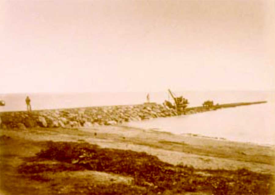
Clearly, the current of the Pasig River directly affected the navigability of the harbor. The meanders were very narrow at the confluence of the San Mateo river, presenting difficulties for the passage of vessels measuring thirty meter in length or more. It posed almost impossible conditions for towing these vessels. The situation forced the channeling of the river in its final track. The engineers planned to modify a portion of the upper region of the Pasig River. Despairingly, this region had four meanders in a one-kilometer extension, three of which were very narrow. Two meanders, therefore, were lowered at Malapatnabato and a small dam was built on the island of Santa Rosa to arrange the layout of the river for easy access. Execution of works to the outside port began in 1885 and reinforced the extension of the levee west and east.34 The west dike that protected the harbor from the sea required urgent attention. The western dock was extended with a leveled initial 125 meters and a total length of 1,800 meters (including the plains), with an average height of 4 to 5 meters above the surface at high tide. This dam was composed of two walls. There was an outside wall covering 1800 meters and there were several interior walls. First, the esplanade had a length of 336 meters and a coastal basin of about 600 meters in length and a number of dividing walls measuring 40 meters each. The extension of the east dock did not begin until 1886, when they began to lay blocks to create the structure during 1886 and the first quarter of 1887. It was expanded into a structure measuring 120 meters long.
The expansion of the outer levees, an increase of protected area and inner dredging allowed the entrance of larger cargo ships, creating a ready infrastructure for international trade at the time. As mentioned in reports presented by the Junta de Obras, it was considered that:
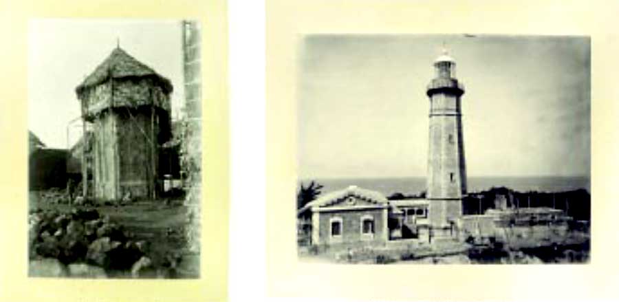
The International Ports of Iloilo and Cebu The ports of Iloilo and Cebu were the main ports of the Visayas islands, located south of Luzon. In these islands, the Spanish administrator repeated the model used for Luzon. He planned the expansion of the ports of Iloilo in Panay and Cebu City on Cebu, and their connection by railroad with agricultural plantations to promote exports. The Cebu railway passed through abaca producing villages. The Panay railroad crossed areas producing rice, abaca and copra. The two lines became profitable from the start in 1907. Planners discussed a possible railway line and port for the island of Negros, the main sugar producer in the Philippines, but because the port of Iloilo in Panay was located directly west of Negros island the traditional boat transport was sufficient.36 The Dirección General de Obras Públicas also began the work of reform and improvement of other secondary ports in the Philippines. In 1875, only Manila, Cebu and Iloilo in the entire Philippine archipelago could receive and dispatch the heavy cargo ships of international trade.37 Manila received the largest amounts of foreign goods, highlighting the importance of yarns and fabrics. Regarding exports, 85% of the "total commercial movement" came from Luzon demonstrating the importance of Manila. Coal extracted from Cebu was an exception as was abaca mainly from Leyte and Samar.38 The expansion of the ports of Iloilo and Cebu suffered a major delay due to lack of funds and resources which focused on the improvement of the port of Manila and in the system and signaling lights later on. As of 1898, the project of the port of Iloilo already had constituted their Board responsible to monitor the works. The project would have begun the following year.39 As for the expansion of the port of Cebu, in 1898 the draft of the port works had not been sent for approval. There was just a request to the Board about the deadline to issue the proposals for the main works. Instead of Iloilo and Cebu, the Board invested in construction of lighthouses and signal systems to facilitate navigation. Until the mid-eighties of the nineteenth century, there were only three lighthouses in the Philippines and only basic port lights. This situation changed in April 1885 when the legislators in Madrid approved funds to light the Philippine maritime coasts with the construction of thirty-five lighthouses along the coast.40 By 1893, eleven lighthouses had been built.41 Moreover, investments were made in keeping coastal ports functioning, though they were often in poor condition due to lack of funds for investment. Baldomero Donnet, an engineer for Public Works in the Philippines wrote:
The War Department of the United States reported that the majority of international trade occurred in the ports of Manila, Iloilo, Cebu, and additionally the ports of Sual, and Zamboanga, although "the coastline of the islands contain a vast number of good ports." But, the information was unreliable as the information came from coastal sailors who had limited perpsectives on international trade.43 Ports and Lighthouses Change Management In 1902, the first American records reported that there were 196 ports operating in the Philippines, while according to the same source, just before the American occupation there were only 63 ports enabled.44 If we look at the list of ports from the census of 1903 compared with the list that appeared in the Revista de Obras Públicas (number 119, dated September 15, 1898), we can see that the vast majority of open ports for the new U.S. administration were outside Luzon and corresponded to other islands. Merchants and sailors used the many natural ports for coastal shipping during the Spanish era. They were not, however, considered to possess adequate infrastructure, such as delivery docks, were barely equipped with lights and supported by wooden structures.
With the arrival of the U.S. administration, especially the Second Philippine Commission headed by William Howard Taft, one of the priorities was improving infrastructure, damaged during the war years. Its first acts allocated resources for the reconstruction of roads and ports, especially around the port of Manila, which were badly damaged during the Battle of Manila. Further Enlargement of the Port of Manila The committee approved a grant for the improvement of the harbor works in Manila and this involved a cost of three million dollars. According to Taft, the situation of the port of Manila was unsatisfactory. Popular thought held that Manila Bay was too small to form a port itself, but Taft believed that this idea was mistaken. The bay had enough width and opened in front of Manila, with an area large enough to protect ships during monsoons, and this enabled loading and unloading during the wet season. The Spaniards constructed part of a dam with this idea but did not complete the project. The planned dike was insufficient for the passage of transport. Failing to finish this project, the Spaniards used the entrance that the Pasig river offered as a port for ships with a depth of five meters, but it too was inadequate. According to Taft:
Improving the port of Manila was also the route that the Spanish government had followed to encourage exports. The difficulties of internal communication were great, especially at the provincial level. Taft believed that there had to be integration of the territory under U.S. administration to stop the rebels who utilized the isolated areas as bases of operations. At that time, the best gateway to these areas was the sea and controlling the ports. To achieve this goal, the commission contracted the construction of twenty small marine vessels expected to carry mail, The police also needed the boats to maintain order and guarantee the transportation of provincial officials between the capitals of provinces and Manila. This would substantially improve the communication between the different areas of the Philippines. According to Taft, "in the current system it sometimes takes longer to reach the capitals of some of the most remote provinces of Manila than it takes to go to San Francisco."46 The Americans widened the port of Manila, following the plans that the Spaniards had developed, but they exerted pressure on the resources to make those features work in a timely fashion. The port of Manila for centuries had remained unprotected against strong winds and typhoons. Cavite, 15 kilometers away from the Pasig River mouth, was the only anchor point for ships too large to enter the river. Nor could steamboats navigate the river when they arrived in Manila. Steamboats had to wait outside the harbor, away from the coast, Carog and passenger vessels were exposed to danger during the typhoon season. The Spaniards began to build a splendid harbor by building a huge dam south from the entrance of the Pasig to deepen the sea coastline, but it proved totally inadequate. By 1914, American improvements improved the cranes and docks. David Barrow declared "even the largest ship in the Pacific Ocean could dock there."47 The service area was expanded, containing updated facilities for transportation and storage. These improvements, which cost about four million dollars, were completed in May of 1908. Impact Coastal shipping was the main transportation system in Luzon in the late nineteenth century. The Spanish administration had made it clear that connecting rail to ports was practically indispensable to modernize the colony. With the union of the railway to the modernized ports, the connection of farms to maritime and international trade as secure, and with it, the most reliable sources of income for the Philippine economy. The network of ports in the Philippines was large enough, since for the most part it was made of natural harbors that worked well enough for coastal shipping. Yet, they were ineffective for heavy transports and international freight because they could not access shallow waters to load the goods. The Spanish government proceeded to make enlargements of the ports of Cebu and Iloilo, along with Manila, under the direction of Eduardo López Navarro, the engineer who was chief of the Directorate of Public Works. The U.S. Administration took up this task along with addressing damages aarising from the Spanish-american War. It began with the reconstruction of bridges, roads, lighthouses and ports in the archipelago, making a special effort with Manila harbor. As a result of the expansion and improvement of the port of Manila,, they began to think of Manila as a distribution center for American commerce in the East beyond just thinking about the growth in production of their own islands. With the construction of stores for U.S. products, many Americans worked to create a shopping center attractive to potential distributors. Wholesalers in the United States with Asian contacts envisioned the emergence of Manila as a major distribution point for North American manufacturers to the East.48 Manila had disadvantages. It lacked consumer markets to attract retailers to invest in it. In addition, it was two to five days of travel from other markets in Asia: the well-established international trading and logistics centers like Singapore, Hong Kong, Shanghai and the coastal cities of Japan. These ports had excellent facilities for the storage and distribution of wholesale goods and monopolized the bulk of regional trade. The Port of Manila was nonetheless sufficiently developed to become a vehicle for the export of products produced in Luzon and it would eventually be of logistical importance in regional trade up to the level of Hong Kong, Singapore, and Shanghai, though its colonial relationship with the U.S. during the first decades of the twentieth century reoriented most transactions towards North America. The importance of the Filipino ports would emerge as they entered into the expansion of American military strategy in the Pacific. After the Japanese victory against Russia in 1905, Japan was perceived by many Americans as a rival for control of the Philippines. And not without reason: the Japanese had initiated a system of spying on the Philippines.49 Although the intent of this system may not have been to prepare for the invasion of the islands, it did seek to encourage Filipinos to rebel in the hopes that the United States would get rid of the archipelago at any price. In response to these activities, in 1907 President Theodore Roosevelt ordered the Military Information Division to submit weekly notes on the activities and intentions of the Japanese in expectation of a hostile movement against the United States. In the Philippines, tensions increased with Tokyo over Japanese immigration, and Roosevelt ordered the Atlantic fleet to cross the Pacific in a show of force. This spectacular demonstration of American naval power was more of a show than a reality and could not hide the fact that the U.S. was withdrawing from the Western Pacific. In the Philippines there was the growing sense that U.S. influence was fading. To counter it, Roosevelt's successor, President William Howard. Taft, ordered U.S. Navy forces from the U. S. mainland to return to Pearl Harbor in late 1909. In the Philippines, the Americans completed construction of the main naval fortifications, located on Corregidor and at Subic Bay.50 Yet, the impact of new U. S. administration in the Philippines in terms of port development is often overblown. The Americans evolved democratic institutions and extended the administrative network throughout the archipelago, with key measures for development such as the universalization of the postal service, education and health systems. Nevertheless, the work of Spanish engineers who traced the outline of the projects that were finally implemented under the better financed U. S. administration has not been sufficiently taken into account. We still find today some of this infrastructure in use in the Philippines. The U.S. Administration did not start from zero. Contemporary observers had no doubt that the U. S. colonial government in the Philippines was continuing Spanish efforts in the development of the transportation network. Conclusion The universalization of the steamers since the mid-nineteenth century, as well as the connection of submarine cables between Europe, Asia, Australia and the United States and above all the opening of the Suez Canal in 1869, transformed maritime communications and boosted export economies. Distribution of mail and newspapers between the metropolis and its colonies motivated the move from sailing to steam navigation. The increase in maritime traffic prompted colonial empires to protect their coasts and ports by reducing piracy. The imperial governments and businesses improved the ports, increasing the traffic and responding to the burgeoning demand for consumption in Europe and the United States of products coming from Asia. Farms expanded and connected through railways to ports, shipping the increasing productions, gaining productivity and reducing costs and lead times. Telegraphs, railways and submarine cables followed. Notably, at the end of the Nineteenth Century we see the emergence of a network of modernized port cities in Asia located on the main maritime trade routes, connected by the telegraph, facilitating the growth in transit of goods, passengers and emigrants, and even colonial era strategic thought, East and West. That development was spurred by the need to serve larger steel hulls and the construction of concrete docks in modern Asia's port facilites, such as at Singapore and Hong Kong,which in turn helped create the cosmopolitan economic and cultural centers they are today. This study has demonstrated that the development of ports in the Philippines may serve to help illuminate this process. Dídac Cubeiro holds a Ph.D. in History from the Universitat Pompeu Fabra in Barcelona, Spain and a degree in Economics and Business (also UPF), specializing in economic history in East Asia. The interest in the East Asian economic reality emerged from research conducted in the dissertation: Communications and infrastructure development in the Philippines: from the Spanish Administration to the North American (1875–1935). He is currently an associate professor in the Department of Applied Economics, Universitat Autònoma de Barcelona teaching the subjects of "Applied Economics in East Asia" and "National and International Markets in East Asia" in the East Asian Studies program. He also collaborates as a researcher with the Consejo Superior de Investigaciones Científicas (Spanish National Research Council) and the UPF Research Group Grup de Recerca en Imperis, Metròpolis i Societats Extraeuropees (GRIMSE) mainly concerning the topic of the impact of the infrastructures in the economic history of the Philippines. He can be reached at didac.cubeiro@uab.cat, Departamento de Economía Aplicada, Universidad Autonoma de Barcelona, ORCID # 0000-0001-5811-7824 |
|||||||||||||||||||||||||||||||||||||||||||||||||||||||||||||||||||||||||||||||
|
|
|||||||||||||||||||||||||||||||||||||||||||||||||||||||||||||||||||||||||||||||
|
Notes
1 This paper is incorporated under the research Project funded by the Spanish Ministerio de Industria under the code HAR2015-66511-P (MINECO/FEDER) by the CSIC, under the name "Replanteamiento de la política colonial española en el Siglo XIX: La modernización de Filipinas, 1868–1898"; in a wider research that tries to understand the way how the Philippines were modernized during the second half of the nineteen century under the Spanish administration. 2 D. North "Ocean freight rates and economic development, 1750–1913," Journal of Economic History 18, no 4, (Cambridge: Cambridge University Press, 1958), 537–555. 3 Daniel R. Headrick, The Tentacles of Progress: Technology Transfer in the Age of Imperialism, 1850–1940 (New York: Oxford University Press, 1988), 23–25. 4 Gary Y. Okihiro, Pinapple Culture: A history of the tropical and temperate zones (Berkeley: University of California Press, 2009). 5 Michael G. Mulhall, The Dictionary of Statistics (London: George Routledge and Sons, 1884), 523. 6 Headrick, 20. 7 Headrick, 28. 8 Dídac Cubeiro, Comunicacions i desenvolupament d'infraestructures a les Filipines: de l'Administració espanyola a la nordamericana (1875–1935) (Barcelona: Universitat Pompeu Fabra, 2011). 9 David R. Meyer, Hong Kong as a Global Metropolis (Cambridge: Cambridge University Press, 2000), 104. 10 Henry A. Van Coenen Torchiana, Tropical Holland, An Essay on the Birth, Growth and development of Popular Government in an Oriental Possession (Chicago: University of Chicago Press, 1921). 11 Paul Bourde, De Paris au Tonkin (Paris: Calmann Lévy, 1885), 113. 12 Meyer, 106. 13 Eduardo López Navarro, Plan General de Ferro-carriles de la Isla de Luzón (Manila: Establecimiento Tipográfico "Ciudad Condal" de Plana y Cª, 1876) and Willis B. Wilcox, Through Luzon on Highways and Byways (Philadelphia: Frank Book Co., 1901). 14 Ian J. Kerr, Building the Railways of the Raj 1850–1900 (Delhi: Oxford University Press,1997), 127–156. 15 Arturo G. Corpuz, The Colonial Iron Horse. Railroads and Regional Development in the Philippines 1875–1935 (Quezon City: University of the Philippines, 1999), 13–27. 16 Edward W. Harden, Report on the Financial and industrial conditions of the Philippine Islands (Washington: Government Printing Office, 1898). 17 John A. Larkin, Sugar and the origins of modern Philippine society (Berkeley: University of California Press, 1993), 59–64. 18 U.S. Commerce and Police Department, Annual Report of the Supervising Railway Expert to the Honourable the Secretary for Commerce and Police for the Fiscal Year 1907 (Manila: Government Printing Office, 1912), 22. 19 War Department, Railways in the Philippine Islands, (Washington: 57th Congress, April 4, 1902) Senate Document 283. 20 La Gaceta de Manila, (Manila: January 4, 1897). 21 Baldomero Donnet, Las obras públicas en Filipinas. Revista de Obras Públicas (Madrid: Colegio de Ingenieros de Caminos, Canales y Puertos de España, 1898), 11–15. 22 Juan M. García Morón, Memoria sobre el progreso de las obras del puerto de Manila. Revista de Obras Públicas (Madrid: Colegio de Ingenieros de Caminos, Canales y Puertos de España, 1899), 21–26. 23 Initially manual dredges were purchased, but once they were tested, and also because the operators did not have enough strength to do the work properly due to the heaviness of sludge extracted, it was decided to purchase a small steam engine that produced movement to perform the drainage. 24 We found among several reviews that engineers discussed the lack of "professionalism" in the execution of dredging work, which was defined as breaking the dredge manual. The primary argument was that the first thing that should have been done was to dredge the lower river closer to the mouth, as it would be at least able to be used by the inner harbor, instead of starting on the inside, which meant that the work was not being utilized until completion. 25 Royal Order of 30 January 1881, which sent a draft for the new port of Manila. 26 The engineer responsible for the work was Eduardo López Navarro, who had also designed and directed the construction of the railway line between Manila and Dagupan. 27 García Morón, 21–26. 28 The location of the storage tanks and the project is under a special section called "Installing workshop blocks" at "Workshop Setup." 29 The Cavite shipyard was owned by a private company, and also ships could have entered with matriculation of Manila, although it was very expensive for small boats. 30 Mud taken from the bottom of the bay was processed as follows: left to dry in the mud and passed through a sieve that separated the fine sand to be used for mortar. Afterwards the gravel was distinguished from the concrete and the rest was collected and the soil was used to fill the terraces. The main problem that arose was that the earth that was extracted was not uniform, most of the times it lacked gravel but it was abundant in sand, and it had unbalanced proportions that had to be corrected. 31 All materials used in the works were purchased at auction where suppliers had offered them for sale. The materials to produce the blocks were divided into three batches: material gauge, material loading and transportation equipment manufacturing or concrete. During October 1885 they received proposals from six manufacturers. The company Brunel was chosen for rail tracks and the company Vignoles was chosen for blogging workshop for transport routes. As for equipment loading and for transporting the cranes they were supplied by Sauter Lemonnier, and steam ferries were supplied by the brand Braine-le-Compte, while cars and platforms to transport units were purchased from Usines et Fonderiet Baume et Marpent. In addition, the mixers were acquired from the English brand Burton. Most of these machines were received during the course of 1886, but parts of one of them became lost and had to be replaced because during the month of June 1886, a ship with cargo disappeared at the Straits of Balabac. Although they telegraphed urgently to reorder the shipment, it did not arrive until February 1887, and they were unable operate the machine until the months of July and August, once it was installed. A few months later, they recovered the wrecked ship and part of the cargo was able to be purchased at a low price, especially certain materials and a six-wagon platform that joined the project. 32 García Morón, 21–26. 33 García Morón, 21–26. 34 The work of widening and strengthening of dikes were performed as mentioned above, first with a base created by boulders and then with concrete blocks as a coating. 35 Donnet, 11–15. 36 U.S. Commerce and Police Department, Annual Report of theSupervising Railway Expert to the Honourable the Secretary for Commerce and Police for the Fiscal Year 1907 (Manila: Government Printing Office, 1912), 22. 37 Both the Spanish and American government chose Manila, Cebu and Iloilo as their main headquarters. In the American case, these three cities were the headquarters of the Court of First Instance. According to William H. Taft, Civil Government in the Philippines (New York: The Outlook Company, 1902), 52. 38 Genaro Palacios, Reseña general sobre la importancia mercantil de la isla de Luzón (Filipinas). Revista de Obras Públicas (Madrid: Colegio de Ingenieros de Caminos, Canales y Puertos de España, 1877), 17–23. 39 Donnet, 11–15. 40 Gaceta de Madrid, (Madrid: April 15, 1885). 41 Donnet, 11–15. 42 Donnet, Las obras públicas en Filipinas. Revista de Obras Públicas, 11–15. 43 War Department, Military Notes on the Philippines, (Washington: Government Printing Office, 1898), 12. 44 Philippine Commission, Census of the Philippine Islands (Manila: Government Printing Office, 1903) 579. 45 William H. Taft, Civil Government in the Philippines (New York: The Outlook Company, 1902), 38–39. 46 Taft, Civil Government in the Philippines, 58. 47 David P. Barrows, A Decade of American Government in the Philippines, 1903–1913 (New York: World Book Company, 1914), 19. 48 Oscar P. Austin, The Commercial Philippines in 1906. Showing the trade of the islands, the chief countries participating there, the principal articles imported and exported, and details of the trade of the United States with The Island during a Term of the Year, Department of Commerce and Labor, (Washington: Government Printing Office, January 1907), 6. 49 Alfred W. McCoy, Policing America's Empire (Madison: University of Wisconsin Press, 2009), 184. 50 McCoy, 184. |
|||||||||||||||||||||||||||||||||||||||||||||||||||||||||||||||||||||||||||||||
|
|
| Home | List Journal Issues | Table of Contents |
| © 2017 by the Board of Trustees of the University of Illinois |
Content in World History Connected is intended for personal, noncommercial use only. You may not reproduce, publish, distribute, transmit, participate in the transfer or sale of, modify, create derivative works from, display, or in any way exploit the World History Connected database in whole or in part without the written permission of the copyright holder. |